This section includes
- the River Kennet at Chamberhouse Mill (and how to get around it)
- a choice of routes from Thatcham or Colthrop down to Brimpton Mill and King's Bridge
- King's Bridge to Woolhampton.
The River Kennet at Chamberhouse Mill
From the put-in on the canal near Thatcham rail station (see Section 2: The Kennet at Thatcham) paddle straight across the canal and up the channel which connects to the river, turning left and up to the road bridge which looks to be too low to get under. It is also possible to enter or exit the river right immediately downstream of the River Kennet road bridge.


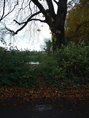
Looking north towards Thatcham rail station, a possible but fairly pointless put-in, as you'd almost immediately have to exit.

Even in later summer low water conditions the road bridge is very low and passage beneath is 'problematic' at best.

Downstream of the road bridge.
It would also possible to enter or exit the river right after a further 150m, where there is a low bank and gap in the hedge along Chamberhouse Mill Lane, but there is no convenient parking here, and the upcoming obstructions make this somewhat pointless unless you can leap the upcoming fish ladder and avoid the long-ish portage around Chamberhouse Mill described below.

A potential take-out just before Chamberhouse Mill.
From Chamberhouse Mill Lane through to the take-out.
At Chamberhouse Mill [SU 529 661] the mill stream flows straight ahead under a couple of low and surface-barred footbridges, and under the converted mill building and driveway to the private residences. To the left the main branch flows down a fish ladder followed by another surface-barred weir and a four gate sluice weir (both of which are topped by a low level foot bridge).

At Chamberhouse Mill [SU 529 661] the mill stream flows straight ahead under a couple of low and surface-barred footbridges, and under the converted mill building and driveway to the private residences. To the left the main branch flows down a fish ladder followed by another surface-barred weir and a four gate sluice weir (both of which are topped by a low level foot bridge).


The fish ladder, weir, sluice at Chamberhouse Mill.
To portage left before the weir (and fish ladder) would mean climbing up the bank and passing through private gardens, so the river at this point is effectively made impassible to paddlers by these obstructions.
By-passing Chamberhouse Mill
Chamberhouse Mill Lane begins immediately after the bridge over the River Kennet between the left hand entrance to Rainsford Farm and the turn in for Thatcham FC as you travel south along the road from Thatcham station (150m walk).
Whether you walk from the station or have a shuttle driver drop you off at the start of the lane, walk past Chamberhouse Mill...

The entrance to the properties at the Chamberhouse Mill site.
...following the right hand bend in the public footpath, and continue along it, turning left at the junction towards Crookham Manor (your shuttle driver could drop you here, but there is no unauthorised vehicular access beyond this point).
...following the right hand bend in the public footpath, and continue along it, turning left at the junction towards Crookham Manor (your shuttle driver could drop you here, but there is no unauthorised vehicular access beyond this point).

Chamberhouse Mill Lane towards Crookham Manor.
Continuing down the lane you will pass the Thatcham Angling Association car park for the Rainsford beat on your left, where a put in would be possible,...
Continuing down the lane you will pass the Thatcham Angling Association car park for the Rainsford beat on your left, where a put in would be possible,...

Through the trees at the back of the carpark and you get to here....
...looking downstream from Rainsford beat.
...but, depending on occupancy it may be worthwhile continuing a few meters further to where the river nearly meets the roadside. From Thatcham station to this point is a 1km walk. A new fence and gate has been erected by Crookham Manor, but the public footpath continues along the road, only veering away from the river just before the private residence.

The new fencing approaching Crookham Manor along the public footpath.
.jpg)
The river is accessible just before you reach Crookham Manor...
.jpg)
...just follow the 'tracks' from the road through the nettles.

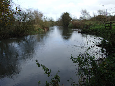
Downstream from the put-in before Crookham Manor
At the end of the run past Crookham Manor, and after only 400m or so, the river branches in two [SU 538 659].
Thatcham to King's Bridge - Northern route
From the divide the River Kennet flows north and then east for 2.4km (1.5m) to Kings Bridge via Brimpton Mill.

Scrapable shallows at low July water levels where the river is broader on this section.
After nearly 1km, Aldershot Water joins river left.
This short channel flows down from the the canal at SU 544 660, and could be used as an alternative access to the river avoiding Chamberhouse Mill. Note that there is a weir flowing from the Kennet & Avon canal into Aldershot Water. See the notes on "The Kennet at Colthrop and Aldershot Water" at the end of this section for further information.

Looking across from the right bank to the inflow of Aldershot Water.

Looking upstream from the left bank just below the entrance of Aldershot Water.

Downstream from the entrance of Aldershot Water.
Otherwise continue on for another 1.2km to where the river widens at SU 553 657, just before Brimpton Mill (disused but in the grounds of a private residence). There is a weir to the right (just before the river passes under the mill) that connects to the now parallel stretch of the southern channel. A portage alongside the fish ladder might be possible if the weir looked unappetising.
Before this point there is another sluice under a footbridge to the left that leads to a ditch channel.

The 'landing stage' on the left bank of the main northern channel marks the end of the NDAA beat and the start of the private Brimpton Mill property.

Downstream of the 'landing stage' where there is a sluices to the left and a weir to the right, but no public access, as the sign on the far bank proclaims (well, "No fishing", but that's probably only because no-one paddles around here).

The drain channel that exits the main river left under the bridge in the background, and then flows under Quaking Bridge and around the back of Mill Cottage (see below) is unfortunately not navigable (the bridge is too low and the narrow watercourse is choked with tree blockages).

From below the weir that flows into the southern watercourse the main flow in the centre can be easily distinguished.
Thatcham to King's Bridge - Southern route
The narrower, shallower and slower southern section flows away over the sluices where the river divides at SU 538 659 after Crookham Manor. These are not shootable but a portage may be possible by taking out to the left of the sluices (main river channel right bank) and bypassing the trees for a couple of hundred meters.
The river then travels for 1.6km (1 mile) until it flows into the weir pool below the main weir outflow from the northern arm just before Brimpton Mill. According to the OS map there are four bridges along this section; the first one is no longer in existance, and none of the remaining three carry public footpaths or provide public access to the river. There are also a number of trees that currently block the surface to through navigation on this section (particularly so just below the sluices), and until these are cleared some awkward portages would be required. Low summer water levels also remove this stretch from serious consideration as a year-round alternative route.
The river then travels for 1.6km (1 mile) until it flows into the weir pool below the main weir outflow from the northern arm just before Brimpton Mill. According to the OS map there are four bridges along this section; the first one is no longer in existance, and none of the remaining three carry public footpaths or provide public access to the river. There are also a number of trees that currently block the surface to through navigation on this section (particularly so just below the sluices), and until these are cleared some awkward portages would be required. Low summer water levels also remove this stretch from serious consideration as a year-round alternative route.

The pool below the main sluiced outflow from the main river. Not the railing at the top of the sluice in indication of the height of the drop here.

The channel down from the smaller sluiced outflow is not navigable.

Looking back upstream, kingfishers dart and herons wade along the first stretch of this section but it's also heavily blocked by fallen trees and, other than after lots of rain, would probably require several walks along the shallow gravel river bed, so is probably best bypassed with the initial portage.

More of the same looking downstream from the same point.

Trees persist as an occasional hazard (and the banks are high and heavily overgrown if you need to portage)...

...and new fencing erected in July 2009 prevent easy exits along some stretches...

...whilst the river remains relatively shallow in some sections throughout the year.

The river continues through private farmland with livestock pasture to the right and arable fields to the left.

The old wooden vehicle bridge at SU 544 656...

...was made redundant by a new metal bridge during the summer of 2009. Both bridges provide plenty of headroom for anyone paddling beneath.

The bridges are just before a small 'weir' that has been formed by debris from the collapse of what appears to have been either a brick-built culvert or another older bridge.

Barbed wire guards a gap in the bank wall.

Approaching Brimpton Mill the southern channel is still relatively narrow and shallow.

At SU 551 658 the southern channel is bordered on the right bank by the grounds of Brimpton Mill to the left and the Wasing Estate to the right.

The stream is only a few parallel meters south of the main river course as it flows to mark the bottom edge of Brimpton Mill.

The fish ladder and weir exiting from the northern channel just before Brimpton Mill.

The southern channel joins the weir pool to the left of the fish ladder in this image, where it is swelled by the outflow from the northern channel

The main river now flows away past disused Brimpton Mill river left.

Looking back upstream from the right bank below the sluice and past the buildings of Brimpton Mill, where the southern channel becomes the main watercourse...

...and, looking downstream, flows out under King's Bridge
King's Bridge to Woolhampton
Below King’s Bridge marks the start of the Wasing Estate’s Warren beat, along which there are no good access points for the rest of this 2.6km (1.6 mile) section.
Below King’s Bridge marks the start of the Wasing Estate’s Warren beat, along which there are no good access points for the rest of this 2.6km (1.6 mile) section.


Winter and spring views upstream from King's Bridge towards the mill race channels flowing below Brimpton Mill - no public access here and no navigable water.

The view upstream from King's Bridge of the main channel...

...and across the road looking downstream, where the southern channel is rejoined by the mill watercourse on the left (just behind the yellow river level gauge).

There is no public access to the river below the bridge. If signs are anything to go by, the main concern of the Wasing Estate used to be illegal fishing with particular focus on some of our Eastern European guests...

...by September '09 new signs had appeared, but they were gone again by mid-December '09. Perhaps it was felt they advertised the potential of a waterway not normally paddled.
There won't be any fisherman on the river between 15 March and 15 June (inclusive) each year, but if paddling outside this 3-month slot, normal river etiquette should be observed even in the face of any verbal hostility.
Below King's Bridge the river flows briefly north before turning east at Mill Cottage (river left).

The view heading briefly north, and approaching Mill Cottage from the opposite right bank.

Looking back upstream from the private garden bank at Mill Cottage, Brimpton.

Looking downstream from the private garden bank at Mill Cottage, Brimpton.
The river winds in a generally NE direction, under two small foot bridges, and then around a small island.

Approaching the first footbridge downstream from Mill Cottage.

Approaching the second footbridge.

The second footbridge from the right bank.

Typical view along this section with shallow spits and deeper channels...

...and it's quite likely that you'll find plenty of trees in the water and overhanging it.
.jpg)
Looking back upstream from SU 566 663 - note the private fishing lake beyond the left bank in the right of the picture. The bank on either side is private Wasing Estate land.
After 2km (1.3miles) there is a dangerously low metal Bailey bridge at SU 567 664, with a public footpath crossing over the river, but access to the banks here is difficult, and you are still on the Wasing Estate’s property. The footpath leads south and then east to the Station Road [SU 572 664], or north to Oxlease bridge over the canal.
.jpg)
Below the Bailey bridge, where the water level gauge has seen better days.
.jpg)
Upstream of the Bailey bridge.
.jpg)
Above the bridge which is only a couple of feet above the water in this image, and would probably require portaging around.
The Wasing Estate's Dalston beat begins below the Bailey bridge (as far as the Rowbarge Pub garden).
.jpg)
Below the Bailey bridge. The flow is faster river right, but river left it passes under the bridge and beneath an overhanging tree hazard.
.jpg)
Downstream from the Bailey bridge.
Continue to SU 571 665 where the River Kennet rejoins the Kennet & Avon canal as you pass under the wooden towpath footbridge immediately downstream of Woolhampton Lock, and just upstream of Woolhampton swingbridge. This point marks the downstream limit of the Kennet as a SSSI (although the official citation states SU 572 667 which is somewhere in the village).

Looking upstream from the put-in/take-out at the edge of the Rowbarge.
.jpg)
Looking downstream from the put-in/take-out towards the canal confluence below Woolhampton Lock.

Looking upstream from the towpath footbridge at Woolhampton. The Rowbarge Pub garden and the end of Wasing Estate Dalston beat is on the left.

The River Kennet rejoins the canal below Woolhampton Lock.
If you want to stay on the water until the next river section, you have to paddle a 1.6km (1 mile) section of the canal to the separation above the Old Mill at Aldermaston.
The Kennet at Colthrop and Aldermaston Water
South of the Colthrop industrial area to the east of Thatcham, is a small loop of the River Kennet that flows out of the canal to the right through a sluice weir just before Colthrop Lock
It's not worth the effort of travelling to in it's own right, but it does provide a convenient parking close to the canal put-in point if you are intending to travel down to Aldermaston Water, and on to the main river above Brimpton Mill.
From the A4 drive down Colthrop lane to Gables Way. Turn right and at the roundabout take the first exit back onto Colthrop Lane. Drive over the railway line level crossing, and turn immediately left. The road is heavily potholed but follow it round to the right and over the canal on the wooden floored bridge. Grundon's Kennetholme Quarry is straight ahead, but turn right again and down to the canal. Pass in front of the row of cottages (one of which displays a nice variation of the 'tradesmen to the back door' sign) and park at the small area of land in front of the weir pool.

A Colthrop cottage greeting.

Approaching Colthrop Weir pool which is an alternative point to park and put-in, but the stream back to the canal is too overgrown at it's end to really justify the effort.

Colthrop weir pool.

Below Colthrop Weir.
The weir at Colthrop was the scene of a lucky escape in 2008: see here (and in case you are completely lacking in imagination, see here!).
The weir at Colthrop was the scene of a lucky escape in 2008: see here (and in case you are completely lacking in imagination, see here!).
The short tree-strewn stream that flows out of the weir pool and back to the canal is not worth entertaining, so, as mentioned above, this area is only really worth consideration as an exaggerated detour around Chamberhouse Mill whilst avoiding a paddle down the canal from Thatcham.
The weir at the top of Aldershot Water exits the canal on the right, but whilst the water flowing through is only partially guarded, the height of the footbridge, and the slope descending on to a flat sill with a crenellated block edge, conspire to make this effectively unshootable.

The weir at the top of Aldershot Water.

Downstream of the weir is a new vehicle bridge out of Kennetholme Quarry. Note the old fishing platform to the right which is now (almost) barred to access.

The view of the weir from the fishing platform.
To portage the weir take out to its left, and climb across a stile that provides access to a track running between the left bank of Aldershot Water and a new extension of Kennetholm Quarry that was started in the summer of 2009.
The track runs past the bridge connecting the quarry over two more stiles (watch our for heavy plant), and you can then either access the Aldershot Water down the sloped bank on your right where anglers have broken through the foliage, or continue down to the end of the waterway and put in where it joins the northern main river channel.

Looking back upstream towards the weir from the quarry bridge.

Looking back upstream from just below the quarry bridge...

...and looking on downstream from the same point river left.
Aldershot Water is only around 265m long, and relatively shallow, but watch out for fallen trees.
Aldershot Water is only around 265m long, and relatively shallow, but watch out for fallen trees.


